by Michael Wright.
It is surprising to realise that the tortuous succession of lanes that now links Warton village to the Yealands, Brackenthwaite, Slackhead and Beetham was once a main road between Lancaster and Kendal. It was in fact a link in the main west-coast route from Lancashire to Scotland.
This winding route only begins to make sense when the original ground conditions in medieval and early modern times are taken into account. The obvious route through the parish across the low ground directly north from Carnforth was barred by extensive areas of soft peat and ground liable to flooding. This had to be avoided by diverting to the east or the west as shown in the map below.
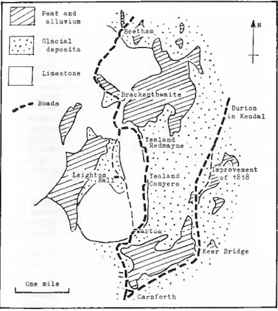
The easterly route skirted the southern edge of the Keer alluvial flat and bridged the river at an easy crossing-point and then continued north past Buckstone House and on to Burton-in-Kendal. Throughout its course this easterly route lay on glacial deposits including gravels and stony clays. There will have been numerous boggy stretches to negotiate, and no doubt the road required regular maintenance, even if that meant simply dumping stone into the wettest places. The great merit of this route was its directness and its gentle gradients.
By contrast the more westerly route through Warton and the Yealands looks positively mountainous in section.
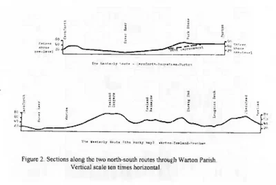
Vertical scale ten times horizontal
Even though the vertical scale on this drawing is exaggerated, there are several genuinely steep gradients on this route (up to 1 in 9 in Yealand Conyers and at Thrang End) What commended the Warton route to the early traveller was its firm ground. It could hardly have been firmer since much of it lay on bare limestone rock. It was a truly all-weather surface, but at the cost of bone-jarring roughness and no doubt a tendency to be very slippery, especially in wet weather. Even this westerly route starts on glacial deposits. The Keer crossing is almost at sea level and then the road climbs a little to get onto the limestone in Warton village. In Warton Lucas commented that “The Street of this Town is rocky and uneven, and abounds with Wormwood…”1 North of the village the road starts a long climb to Yealand Conyers, following the eastern edge of a shelf of limestone, and overlooking the drumlins of the glacial deposits to the east. The steep hill at the north end of Yealand Conyers appears to take the road off the limestone for a few hundred yards, but in Yealand Redmayne it is back on the rock and it stays on it for most of the distance to Slackhead.
The low maintenance requirements of the westerly route would be especially advantageous in medieval and early modern times. There was no official mechanism for the care of medieval roads, but some would receive attention from local monastic houses if they used the routes regularly. It was only in 1555 that responsibility for highway maintenance was put upon townships by the Highways Act. This stipulated that each township must appoint a surveyor from among its residents. The surveyor was unpaid and untrained, but was expected to supervise maintenance of the roads. Residents of the township were required to provide labour for four days in the year, as well as horses and carts. The two through roads must have placed a considerable burden of work on Warton’s townships since there was no outside help with maintenance of roads that had regional or national importance The system was a very unreliable mechanism for keeping roads passable. Travellers through Warton parish would soon learn that if there had been enough rain to soften the damper or more clayey ground they would be best advised to take the rocky westerly route.
But what traffic did these roads have to cope with?
Population levels were very much lower than they are today, but farming was very much more labour-intensive and there would be a very high volume of local travel from farm and cottage, on foot and on horseback to field and peat-moss as well as to the local markets and to fishing grounds in Morecambe Bay. Most of the long-distance traffic passing though the parish would also be on foot or on horseback, and there would be packhorse trains, including those moving between Kendal and Lancaster, and places further south. A few long-distance travellers have written of their experience of using the rocky Warton route. John Leland rode this route in 1539 and after noting that “Warton is a pretti streat for a village” he comments that “The ground beyond Warton and about is veri hilly and mervelus rokky onto Bytham a v. miles of..”2.
In October 1704 Bishop Nicholson of Carlisle was making his way in the other direction. “In company with a deal of Kendale-friends” he took “the rocky way to Warton” before continuing to Lancaster and Garstang.3
Celia Fiennes found the route steep and stony. She was pleased to divert from the road at Warton to ride through Leighton Park, intending to visit Lady Middleton, the widow of Sir George. She found that the family were not at home but had “a free passage through on to the road againe”, presumably at Yealand Conyers as she will have used the Middleton’s road from the Hall leading to the New Park on Yealand Common. She had rejoined the road immediately before one of its worst stretches, from Yealand Conyers to Thrang End and she comments that much of it was “stony and steep far worse than the Peake in Darbyshire … ” 4.
Apart from the few carriages of the wealthy, the wheeled traffic on the parish roads probably consisted almost entirely of the local farm carts. In his “General View of the Agriculture of Lancashire” published in 1815 R.W. Dickson writes that the favoured cart in the north of Lancashire at the end of the eighteenth century was a two-wheeled light cart measuring only 3ft 6in in width and 4ft 8in in length, and pulled by one horse. Experiments with larger, two-horse carts had been carried out but these were found to be very difficult to use in hilly terrain. By the beginning of the nineteenth century the carts had spoked wheels, but in earlier times they had clog-wheels made from thick ash planks secured by dowels. It is very likely that it is this type of cart that is so frequently referred to in inventories of the seventeenth century. Then there would be some heavy loads to move locally, especially timber. Perhaps some larger wagons did try to negotiate the steep gradients of the westerly route. Is this why Thomas Clarkson kept no fewer than eight oxen (inventory of 1649)? Perhaps there was money to be made from helping the heavier vehicles to negotiate the steep hills near his farm al Brackenthwaite.
The establishment of a market in Burton-in-Kendal in the 1660s must have considerably increased the traffic on the easterly route. Further traffic increases by the middle of the eighteenth century made it essential to improve on the north-south routes through Warton Parish. By this time the roads had to cope with fast coaches and the large-wheeled horse-drawn waggons that were replacing packhorse trains. Turnpike trusts were set up to invest in suitable routes, and when it came to improving one of the roads through Warton there could be no doubt about the choice. The easterly route was less hilly and more direct, and if money could be invested in improving the road surface then there was no need to consider the winding, hilly westerly route. A turnpike trust was set up in 1751 to improve the easterly route, while the “rocky road” reverted to purely local use and has remained a local road ever since. Meanwhile there were further improvements to be made to the easterly route. There were still two awkward hills to negotiate, one just outside Carnforth and the other near the Buck Stone. It required a further turnpike trust to be set up in 1818 to deal with these hills. A new length of road and a new Keer bridge were constructed north of Carnforth on the Carnforth-Milnthorpe Turnpike. And a branch of this road linked onto the old easterly route near Heron Syke, crossing the route near Longlands Hotel and sweeping round the foot of the hill east of Buckstone House, so by-passing the hill past the Buck Stone.
In the twentieth century many local authorities and utilities have discovered to their cost just how many of the local roads cling to the limestone bedrock routes. Contractors have struggled to dig trenches to bury water-pipes, telephone cables, power cables and gas pipes, and only recently has this work been made feasible at reasonable cost by the use of diamond saws.
Notes
- J. Rawlinson Ford & J.A. Fuller-Maitland, John Lucas’s History of Warton Parish, 1931, p27 ↩︎
- The Itinerary of John Leland in or about the years 1535-1543. Edited by Lucy Toulmin Smith v.4, 1964, p11. ↩︎
- Bishop Nicholson’s Diaries: Part II, by the Bishop of Barrow-in-Furness. Trans. Cumberland and Westmorland Antiquarian and Archaeological Society New Series v.2, p211. ↩︎
- The Illustrated Journeys of Celia Fiennes 1685-c1712. Edited by Christopher Morris, Macdonald, 1982, p165. ↩︎
Published in the Mourholme Magazine Issue 35 1999