
by Michael Wright
One of the most profound changes to Silverdale’s agriculture and to its landscape occurred in 1817 when seven hundred acres of remaining open commonland was divided up and enclosed. The commonlands lay around the edge of the township, surrounding a core area of better agricultural land that had been, in the words of the enclosure award, “anciently inclosed”. The text of Silverdale’s enclosure award is held at the Lancaster Record Office in Preston, and we are fortunate that there is an accompanying plan, which makes it relatively easy to plot the extent of the former commons. (For adjoining Lindeth, which was part of Warton-with-Lindeth Township, there is no accompanying plan, which makes interpretation of the award more difficult.)
Silverdale’s commonlands originated from the “manorial waste” – land which could not be easily cultivated because the soils were too shallow or the ground too rocky. It is no surprise that this ground roughly coincides with the area formed by the tough Urswick Limestone. It contrasts with the gentler, lower ground of the “anciently inclosed land” in the middle of the township. Here the less tough Park Limestone has been splintered by Ice Age frosts and ground down by invading Pleistocene ice to form a gentler topography. Much of this lower ground has also acquired a thin layer of glacial deposits and downwashed sediment. All this has left Silverdale with a core area of arable land – not very good quality arable, but the best available in the township.
The division of Silverdale’s land into an inner area of arable ground surrounded by rough ground that could be used for grazing and browsing lent itself very readily to a system of agriculture that made good use of all the land. Most landholders wished to grow what arable crops they could, and they also wanted to keep some sheep and possibly a few cows. In the days before artificial fertilisers the dung from the animals was especially important. During the winter months the animals could be allowed to graze on the arable area, fertilising it. But in the growing season they must be kept off the arable ground and sent onto the surrounding commonlands. It was one of the functions of the Manor Court to organise the removal of livestock from the area needed for growing crops in spring and summer. On a specified date the arable area (which in medieval times included open town-fields) was closed off by means of gates at the places where roads led from the common into the arable area. For example at the Silverdale Manor Court of 1 August 1677 it was laid down that “the field shall be driven the fifth day of April and the hedges to be made good against that day and yeats [gates] hung in pain of everie default …. 1 shilling.”
The location of three of the Township gates are shown on the plan – Bradshawgate (G1), Emesgate (G2), and Ford Gate (G3).
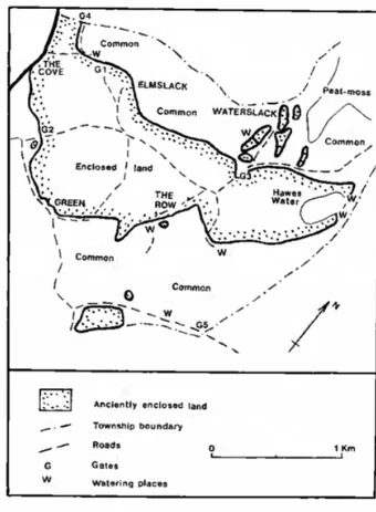
There are other gates mentioned in the Manor Court proceedings, but these have not yet been located. For example on page 114 of the Manor Court records Thomas Clarkson is given the liberty of taking from the common a parcel of land adjoining his own land to make a garden, in consideration of “hinging, taking down and housing of the winter gap yeat annually“. It was also essential to have a good gate on the pinfold, which was situated near the junction of Cove Road and Emesgate. In 1678 the Manor Court directed that William Atkinson was to keep the pinfold in good repair and ensure that the pinfold gate was hung when all the other gates were hung and taken down when all the other gates were taken down.
There were gates on the township boundary too. One, on the Arnside road north of the Cove, let travellers through the ancient wall that runs along the county boundary (G4). And after 1778 anyone travelling along Yealand Road near Trowbarrow would encounter yet another gate (G5) on the boundary between Silverdale Township and Yealand Redmayne Township. This had become necessary to keep Silverdale stock from wandering into Yealand once Yealand had enclosed its commonlands in 1778. As part of this enclosure a wall was built along the township boundary (linking onto the earlier New Park wall) just to the east of Trowbarrow.
To many people travelling through Silverdale the Township gates, closed during the growing season, would be no hindrance. The route from Silverdale Shore up to and along Stankelt Road to the Green lay just to the south of the ancient enclosed land. And travellers from the Cove going east could by-pass the gates by diverting onto the ancient track that goes from Bradshawgate along the northern edge of the anciently enclosed land to Waterslack and beyond. The older farms in Silverdale are all located on the boundary between the commonland and the core of arable land. This is most likely the result of the need for farms to be close to a water-supply. There are few sources of water in the Park Limestone of the arable lands, but small springs and some ponds do occur within the Urswick Limestone ground that formed the commons. It made sense to build close to a water-supply, and with ready access to the arable ground. With direct access to the commonland on one side of the farm it would be easy to handle livestock, and to supervise its grazing. It seems that as far as possible the enclosure award commissioners allocated to each landholder a piece of commonland that lay adjacent to his farm. No doubt this was usually the patch of the commonland that the tenant had habitually used. Not only was it convenient to be able to supervise stock when it was close to the farm, but there was also a Manor Court ruling that if a tenant should gather any manure from the common it must be within three roods of his own ground (Silverdale Manor Court 1678). This ruling evidently tried to ensure that a tenant collecting dung from the common was only collecting the manure from his own stock.
One problem that arose from enclosing the commons was that watering places that had been habitually used for livestock grazing freely on the commons would now be cut off from general access. As a result, careful provision had to be made by the Award Commissioners for permanent access to most of the more important watering places. These are shown on the accompanying plan. Of special interest are the two watering-places on the edge of Haweswater, which were provided to replace the general access to the north end of the lake when the commons were open. Long access roads had to be kept open to these two watering places so that stock could be led to the water without entering the surrounding fields.
From the perspective of the year 2000, when wildlife and flora of the Silverdale area are seen as important assets, it is easy to view the disappearance of the commons as a loss. But in 1800 there was a growing population and a fear of food shortages during the Napoleonic Wars. It was felt that much better use would be made of the land if it was privately owned and enclosed. Not only could stock handling, and breeding, be much better facilitated, but it was also found that some areas of the commons could be cultivated. For example the former commonland between Cove Road and Wallings Lane, which was allocated to Thomas Jackson of The Cove at the time of the enclosure award, is shown as arable ground on the Tithe Award plan of 1846, as is also part of the Lots.
Published in Mourholme Local History Magazine Issue 37 1999