
by Michael Wright
Eaves Wood forms a beautiful backdrop to the northern edge of Silverdale and is part of a ridge of higher ground that extends round two sides of the ancient cultivated fields of the village. There is very little documentary evidence concerning its history, but changes over the last two hundred years can be traced from maps. The earlier history of the area, and the assessment of the extent of woodland cover at different times can only be inferred from general historical information. This article puts together the information at present available and sets out a broad historical framework into which it is hoped more detailed information can be slotted as it comes to light. In particular it would be of great interest to estimate the age of the older trees in the wood and to try to determine which are self-sown and which are part of the planting scheme of Thomas Inman, who owned much of the area in the first half of the nineteenth century and who transformed the appearance of this part of Silverdale.
Eaves Wood is the name loosely applied to the whole hillside which extends for one kilometre from Castlebarrow in the west through King William’s Hill and Eaves Wood proper to Waterslack Woods in the east. These separate sections originated in the divisions set up when Silverdale common land was allocated to private owners at the time of the Enclosure Award in 1817. Eaves Wood extends downslope to the edge of Silverdale’s medieval arable fields, and upslope as far as the crest of the slope. The hill is formed of Urswick Limestone, part of the Carboniferous Limestone Series. At the time of its formation as banks of shelly debris in shallow tropical seas 340 million years ago the deposition of the Urswick Limestone was interrupted from time to time by falls in sea level. These exposed the shelly material to weathering, which dissolved and re-deposited the calcium carbonate of the shells, forming an extremely hard crust. Rising sea level submerged this crust, and the muddy sediment that later washed into the area formed a thin shale layer on top. Repeated oscillation of sea-level led to the formation of dozens of hard layers within the Urswick Limestone. Later weathering and erosion by glacial ice has uncovered these layers which now form areas of limestone pavement. Most have been tilted from the horizontal by earth movements so that they form inclined terraces in many places up the hillside. The thin shale layers that were sandwiched between the thick limestones at intervals of ten metres or so have an important effect on groundwater. They impede the downward seepage of groundwater through cracks in the limestone, and give rise to small springs on the hillsides.
Since so much of the weaker and softer material has been scraped and plucked away from the hill by glacial erosion, it follows that the soil cover is generally very thin or absent, except where pockets of sediment have been washed down the slope after the ice melted, or where windblown silts from Morecambe Bay have settled in hollows on the hill. Consequently our hillside has always been a fairly barren place, and was never suitable for arable cultivation. We do know, however, that a thick woodland cover grew over the whole area after the ice had finally melted and the climate had warmed to something close to the present temperature. Shrubs and trees can establish themselves in the least hospitable environments, including the clefts or grikes in the limestone pavements. Only the broader areas of rock pavement would remain uncolonised by trees.
Pollen preserved in the successive layers of sediment in nearby Haweswater Moss tells us that the early woodland cover included hazel, oak, birch, holly, yew, elm and small-leaved lime, among other species. This assemblage resembles the woodland cover that develops at the present day when the ground is left to revert to nature, but there are some recent introductions such as beech and sycamore. This post-glacial forest could be regarded as the “natural” state of Eaves Wood. However, ever since the Ice Age man has made his presence felt, and the subsequent history of the woodlands can be viewed as a balance between natural regeneration of woodland and man’s interventions for farming, hunting and tree-cutting for timber, wood and forage. We know that Neolithic man lived in the Silverdale area and had an impact on the vegetation, and though we do not yet have certain evidence it is very likely that in the Bronze Age, when climatic conditions were favourable and population rose, there was a considerable demand for ground that could be cultivated. One such area was the low ground south of the Eaves Wood hillside.
The area in Medieval Times.
We have a little more information when we come to medieval times. At the end of the 11th century the area had a low population density, and our hillside may well have been extensively forest covered at this time. All land was controlled by the Lord of the Manor. Areas such as Eaves Wood hillside could not be cultivated and were termed “waste”, though in fact they were exploited extensively for wood and timber, hunting and, as time went on, for grazing animals. As in other parts of England the population would have risen during early medieval times, and this led to more and more land being brought into cultivation. It is very likely that by the 14th century this forest had thinned markedly as the demands on its resources had grown. The establishment of the Silverdale pottery, situated in the area north of Cove Road, will have further depleted the woodland for fuel supplies. Was it fuel shortage that led to the pottery’s closure (possibly as early as about 1600) while rival coal-fuelled potteries such as that at Burton-in-Lonsdale continued to prosper?
The first of the two accompanying plans shows the likely distribution of arable land, roads and tracks in medieval times. The Eaves Wood area was open commonland, probably with some trees that were lopped for small wood and winter forage for farm animals. Along the foot of the slope, skirting the northern edge of the cultivated fields, was the ancient track that linked the Cove to Elmslack and which went on to Waterslack and beyond. This track could have been used by those on foot, or on horseback, and perhaps also by packhorses. Wheeled traffic, if any, was probably limited to two-wheeled farm-carts.
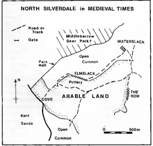
By far the most impressive relic of medieval times in the Eaves Wood area is the wall that now forms the boundary between Lancashire and Cumbria. It is up to six feet high, four wide at the base and three feet wide at the top. The most likely explanation for the width of this wall is that it was originally eight or nine feet high, and that the top has been robbed for use elsewhere. There is good evidence that this was the wall of a medieval deer park, since it is named as Middlebarrow Park Wall in the Silverdale Enclosure Award document of 1817. The northerly extent of the park has not yet been worked out, but no doubt it reached as far as Arnside Tower, or a predecessor of that structure. Walls on the other sides may have been removed for use elsewhere or these sides may have been protected by wooden palings. This park and the well-known Arnside Park northwest of Far Arnside, must be the two referred to by Hutton in his Beetham Repository [p.103]. While the main purpose of the wall was to keep deer in, it would also serve to ensure that grazing animals from the Silverdale side were kept out. It may also have served to discourage Silverdale inhabitants from collecting timber and wood from the north side of the hill.
The Seventeenth and Eighteenth Centuries.
The setbacks caused by a deterioration in the climate, the arrival of the Black Death, and the effects of Scots’ raids into the area led to a sharp drop in the population in the 14th century. Pressure on land resources eased, and the woodland cover of our hillside may have had a chance to regenerate. But by the 17th century the population had risen again and was once more straining resources. The number of people striving to make a livelihood from the land was even higher than at the start of the 14th century, but the climate remained poor and unreliable. Silverdale and Warton Manor Court records contain many references to overgrazing of the commons, and records of Customs of the Manor show that collection of wood from the commons was strictly controlled. Wood burning had long before given way to peat burning, and the local mosses were dug up and steadily consumed on hundreds of domestic hearths, at least by those fortunate to have both hearth and peat.
In the 1630s the 120 or so residents of Silverdale had to grow food for themselves and also had to find grazing and fodder for well over 700 sheep and more than 100 cattle and horses, and this in the days before artificial fertilisers. Arable land was scarce, and there is no doubt that the local husbandry was very dependent on salt-marsh grazing and browsing on the commons. It is very likely that the woodlands were severely depleted, and only scattered individual large trees survived, even these being lopped for fodder. The hillside remained open common land until the Enclosure Award of 1817. But before the changes brought about by enclosure are described there is some information from the earliest maps of the area to consider.
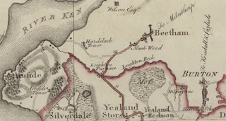
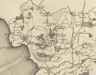
Yates’ map of Lancashire (1786) on the scale of one inch to the mile, is the first map of the area that shows any detail. It is much less accurate than the later Ordnance Survey maps, but it does give us a glimpse of pre-Enclosure Silverdale. It appears to show open unwooded land over the whole Eaves Wood hillside. but thick woodland over the county wall on the north (Arnside) side of the hill. The only other map of similar date, the Greenwood map of Lancashire of 1818, was published immediately after enclosure. In contradiction to the Yates map it shows woodland on the central and eastern part of the Eaves Wood hillside, though it is of course separated from Yates by over 30 years, time enough for considerable changes. Since the extent of woodland cover at the time of enclosure is of some interest it would be useful in future to search for the oldest trees in Eaves Wood to see whether any were growing when the area was still open common land.
Enclosure, Thomas Inman and Hill House
The enclosure of the commons came about in response to a need for farmers to have greater control over their livestock and over the exploitation of the grasslands and woods. The common lands which had stretched all the way from Castlebarrow to Waterslack and beyond were-finally allocated to individuals and walled off, the amount allocated to each individual being proportional to that individual’s grazing rights on the common, held by virtue of tenancies in the manor. It is at this time that Thomas Inman enters the story. He was from a prosperous family of merchants based in Lancaster. Directories describe his father, Robert, as a merchant in the late eighteenth century, and in all probability, Robert had interests in shipping. His son Thomas was born in about 1780, and is listed in directories as a timber merchant, an occupation that may well have evolved from shipping interests. His business premises were at Green Ayre, and he had a house in Fenton Street in Lancaster. But he also clearly aspired to being a country gentleman and set up house in Silverdale at Hill House (later re-built and re-named Woodlands). A sale catalogue of 1851 [Lancaster Public Library Reference Dept.] refers to Hill House as Thomas Inman’s summer residence. He also bought a great deal of land in Silverdale and by the time of the Tithe Award in 1845 he was the largest landowner with 240 acres. About 80 acres of this was common land that had been allocated to him at the time of enclosure. In fact,he was allocated all the hillside behind Hill House, while the common further west (Castlebarrow) was allocated to William Machell, and the common near Waterslack was allocated to Thomas Kellett.
It is quite evident from his subsequent work on his “estate” that he was determined to establish a rather grand country seat with associated gardens and ornamental grounds.
Even before the Enclosure Award of 1817 he had owned the fields that lay along the foot of the Eaves Wood hillside. Now that he owned the whole hillside down to the road from Silverdale Chapel to the Row he removed and rebuilt walls, reshaping the fields on the lowest ground. Small areas of woodland that had been in the fields were now incorporated into plantations higher up the hill, and the fields were enlarged. The field closest to Hill House was designated The Park.
As to his 80 acres of allocated common land, he built a wall to divide this into two sections. The eastern section, Eaves Wood, he used for coppiced woodland, but he evidently planted specimen trees here as there are still many mature beeches, including beech circles. The small cottage in Eaves Wood was built for a gamekeeper. It is now in ruins, and was ruined as early as 1872 when it was described in an item in the Lancaster Guardian [issue of June 22]. It must have been used at some time by a fisherman, for the ground around is full of cockle-shell fragments. The western section of Inman’s allocation of common land (Cragg) was left as pasture, but Inman made two plantations within this pastureland. The larger of these is on King William’s Hill, the ridge of ground just behind Hill House. The name of the hill is thought to commemorate the accession of King William IV in 1830 and there are remnants of the foundations of a hexagonal gazebo on the western end of the hill, probably of the same date [David Peter, “In and Around Silverdale“, p.64]. The first edition Ordnance Survey map (1848) shows a flagstaff on the slope of the hill.
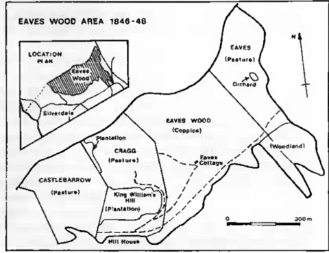
The second plan drawn to accompany this article has been complied from the Tithe Apportionment plan of 1846 and the First Edition Ordnance Survey map of 1848. The walls shown enclosing the two plantations have now almost disappeared, and apart from a large number of beech trees in the plantation on King William’s Hill, the original plantings are now difficult to determine.
Presumably the gazebo, when built, had clear views over the trees in the plantation, but now, its site is deeply buried in woodland. At the present day the main legacy of Inman’s landscaping work is the pattern of tracks along and up the hillside. One of these, known as Inman’s Road, follows roughly the same line as the medieval route along the lower part of the hillside, to Waterslack. A note added to the Mourholme Society archive copy of the Silverdale Enclosure Award claims that Thomas Inman illegally stopped this right of way in about 1830.
Eaves Wood from 1851 to the present day
Thomas Inman died in 1851, leaving the estate to his wife but giving his gardener, William Williams, the property known as Green Close, on Silverdale Green. The estate was put up for auction in June 1851, when the sales literature remarked on the drives and walks in the plantations and other parts of the estate and the views from the house. The timber and coppice wood were said to be thriving, so it is evident that Thomas Inman had maintained his interest in tree growing. Despite the glowing description of the estate “in the Romantic District of Silverdale” it appears that the reserve price was not reached at auction. The estate was offered for auction again in 1857, after being more widely advertised in Manchester and London. Silverdale railway station was about to be built, and this time the possibility of building villas on parts of the estate was raised. By 1858 Hill House and its adjoining land were in the ownership of Christopher Wood. He rebuilt the house and named it- Woodlands. Subsequent changes in ownership are described by David Peter [“In and Around Silverdale”, p.60]. In 1873 the property was bought by a cotton spinner from Bolton, John Hebden, and after his death his wife lived at the house till 1905. The 1905 sale catalogue for the house and grounds [Lancaster Public Library Reference Department] shows that the extent of the estate around the house was still much the same as when Inman owned it. Ordnance Survey maps of 1891 and 1913 show the same hillside features as were shown on the 1848 edition, and it seems very likely that little of Inman’s original landscaping was altered by any of the later owners. But the change that does become apparent by comparing the maps is the gradual spread of woodland over the whole hill. By 1891 woodland had spread over the former pasture on the Cragg, and had absorbed Inman’s plantations. Woodland had also spread over the eastern end of the hillside, in the area above Waterslack. In 1891 Castlebarrow is shown as still remaining as open pasture (and this is confirmed in some early photographs[NG1] of this end of the hill). By the time the 1956 Ordnance Survey map was published there were patches of woodland on Castlebarrow, and in the last few decades the whole area has become wooded. This inexorable advance of woodland has recently been checked and in some places reversed by the present owners of the land, the National Trust.
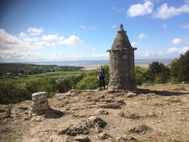
Two other features of the hill remain to be mentioned. In 1887 the Jubilee Memorial (“the Pepper Pot”) was built on Castlebarrow, and the 1891 Ordnance Survey map shows a flagstaff downslope to the southwest, on what was then still open ground. And a memorial of a different sort, the huge water-storage tanks that lie at the lower edge of the woods, just behind Woodlands, are testimony to Silverdale’s problems with water supply in the years before mains water arrived in 1938. These tanks, with estimated capacity of 40,000 gallons, were probably built by Mr Pratt, who had bought Woodlands in 1905. In 1907 he opposed the introduction of mains supply to the village claiming that small springs on the hillsides could be tapped. He had just invested some hundreds of pounds in such a system for Woodlands and some nearby cottages [Lancaster Guardian 14 December, 1907]. Remains of this system of pipes and tanks can be seen extending right up the hillside almost to the crest of the hill, collecting the very small flows from those shale bands within the layers of Urswick Limestone. Mr Pratt cannot have built all this, however, because there is a reference to one of the tanks up the hillside in a Lancaster Guardian article of 1872 [June 22]. Whether Mr Inman had installed some of this collection system is not known. He may have relied on roof water as did others who had slate roofs. The size of Mr Pratt’s tanks indicates the problem of storing enough water to keep a supply flowing in drought years.
This review of the history of Eaves Wood shows that we owe a great deal to Thomas Inman’s landscaping work which transformed the open common land into a pleasing mixture of open pasture and commercial and ornamental woodlands. Much of the design that he brought to the hillside has been blurred and swallowed up by the natural spread of woodland cover over the whole area, but features that survive are his plantings of beech trees, and the network of tracks that give access to all parts of the hill. Owners since Inman’s day seem to have made few modifications to his design, and the spread of woodland remained unchecked as livestock grazing diminished. In 1929 Mr F.J. Dickens gave Castlebarrow to the National Trust, and after Mr Dickens died in 1949 the Trust acquired King William’s Hill, Eaves Wood and Waterslack Wood. Later acquisitions by the Trust near Woodlands and opposite the Row give ready public access from Park Road. Recently the National Trust has been clearing some of the natural woodland to create open areas which will provide more varied habitats for plant and animal life. In other parts of the wood a coppicing cycle has been started. These activities have been criticised by some who had become fond of the wild, spreading woodland. But some cutting and coppicing seems quite reasonable when viewed in the context of the changes that have taken place over the last two hundred years. In any event, it is clear that Eaves Wood will remain a very valuable recreational asset for Silverdale.
Maps and Plans Consulted.
1786 Yates’ Map of Lancashire
1817 Silverdale Enclosure Award Plan [Lancashire Record Office]
1818 Greenwood’s Map of Lancashire
1846 Silverdale Tithe Apportionment Award Plan [Lancashire Record Office]
And Ordnance Survey maps and plans dated 1848 (six-inch to the mile), 1891 (1:2500), 1913 (1:2500) and 1956 (six-inch to the mile).
Post-script:
Since writing the above I have found evidence that it was Robert Inman who bought Hill House and the surrounding land in 1808. At the Enclosure Award of 1817 he was allocated the area of common above Hill House, and all this property was passed on to his son Thomas when Robert died in 1823.
Published in Mourholme Local History Society Issue 34 1998