By A.C.H. Olivier (Assistant Director of the Cumbria and Lancashire Archaeological Unit)
Excavation of a circular dished earthwork c35m in diameter was undertaken by the Cumbria and Lancashire Archaeology Unit in advance of gravel extraction. Work was conducted on behalf of the Department of the Environment with the permission and support of Tilcon, Ltd, between 8 August 1982 and 22 October 1982. This hitherto unclassified earthwork lay on the crest of a small fluvio-glacial hillock 13.5m above ordnance datum (SD 523725), directly overlooking the valley of the river Keer as it runs into Morecambe Bay. The entire area is underlain by carboniferous limestone.
Total excavation of the feature revealed a substantial sub-circular enclosure of large limestone boulders (0.4 to 0.7m high), completely covered by a cairn of smaller stones and pebbles. The site of the enclosure had apparently been deliberately prepared and cleared prior to the construction of the monument. No trace of an old ground surface was recorded below the enclosure, and the buried coil was identified as a truncated stagno-podzol1, which was therefore considered unsuitable for thin sectioning. The pH of this horizon was 7.352, and therefore too high for non-differential pollen preservation. Although some of the boulders were clearly derived from the immediate fluvio-glacial deposits surrounding the site, the great majority displayed erosion patterns consistent with long exposed pavement limestone, and were probably transported to the site at Manor Farm from nearby limestone outcrops either at Warton Crag or Hutton Roof 2-3 miles distant.
The eastern and southern perimeter of the enclosure was extremely well defined by a carefully placed free standing kerb composed of a single outer course of slightly smaller boulders. The main body of the enclosure was most substantial to the north where it survived in places to a width of around c.9m and was several courses of boulders thick. Although varying considerably in width and thickness, no easily identifiable pattern could be observed in the structure of the enclosure. It was therefore difficult to distinguish whether the location of some internal boulders was the result of deliberate positioning or merely tumble derived from either natural erosion or perhaps deliberate slighting.
Close to the centre of the enclosure lying in situ on the cleared ground surface, immediately beneath the smaller stones of the overlying cairn, was the surviving portion of a contracted inhumation burial, lying on its left side. Associated with this burial were two very well preserved bronze grave goods – a simple Early Bronze Age Flat Axe, and a flat rivetted dagger blade of the same date. The blade of the dagger is triangular (although the tip is missing), with three stout plug rivets, probably belonging to Gerloff’s type (Masterton, 1975, p.58), no trace of the handle survived. A second inhumation was recorded with a ‘cell’ of limestone boulders along the inside edge of the southern portion of the enclosure. This burial was in an extended crouch, lying on its right side, laid on the flat cleared surface immediately below the stones of the cairn. The bones only survived partially, in a very fragmentary condition; however the skeleton was clearly associated with a second, less well preserved Early Bronze Age flat dagger blade, of similar form to the example described above. The presence of this inhumation in an apparent cell highlights the possibility that other negative areas of boulders within the body of the enclosure may also have been ‘burial cells’, although no traces of such use survived.
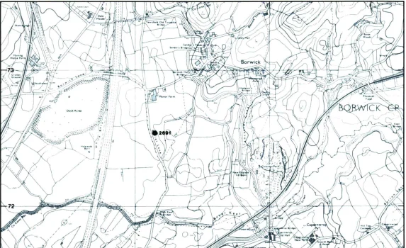
Approximate site of cairn, Manor Farm, Borwick, now destroyed The overlying cairn of stones was clearly of one single build, and although large quantities of fragmentary human skeletal remains were recovered during its removal, it was not possible to make any real stratigraphic distinction amongst this material. The positions of all skeletal remains were recorded and plotted three dimensionally, and the scatters of inhumed bone formed a number of fairly discrete concentrations (c.11), generally limited to areas of c.l-1.5m diameter. Most of these concentrations were completely unrelated to the location of cells within the underlying boulder enclosure, and it is possible that they were derived from earlier burials disturbed by and presumably mixed with the construction of the cairn. Such burials may have consisted of bodies either laid and exposed on the cleared ground surface inside the enclosure, or under individual cairns which were then disturbed by and completely mixed with the later covering cairn, No physical trace of any such smaller cairns was observed during the excavation of the overlying calm. A phosphate survey of the cleared ground surface was conducted at 50cm intervals and it is hoped that analysis of these results may indicate the original presence of such inhumations as well as the possible existence of additional inhumations (now completely decayed) within some of the ‘cells’ of the enclosure3.
The problems of interpreting such analysis are of course recognised; positive results may do no more than reflect the locations of the bone concentrations already identified, and indeed may merely derive from these concentrations by the downward leaching of phosphates through the cairn. Seven discrete concentrations of cremated bone were also recorded mixed with the main body of cairn material. These scatters ware slightly more extensive (c.l.5-2m) than those of inhumed bone, with which they wore generally mutually exclusive. The cremated material was also mixed with quantities of extremely small and fragmentary Bronze Age Pottery (mainly recovered as a result of dry sieving). This pottery was in very poor condition, few sections across the wall of any pot survive and most pieces are merely core fragments. Those fragments of external face that do survive are so small that it is difficult to judge whether the pots were originally plain or decorated. Although in poor condition the pottery associated with each cremation is of fairly high quality and presumably represents some form of funerary urn; it is unfortunate that no more detailed classification is possible. The cremations describe a general arc in the south and east portion of the cairn which appears to be eccentric to the underlying enclosure. A possibility therefore exists that although the cremations occurred in the same stratigraphic position as the probable inhumations described above, they may actually represent insertions into the surface of the existing cairn, perhaps sometime during the Middle or Late Bronze Age. However, if this was the case, it was certainly not possible to observe such insertions in the cleaned surface of the cairn.
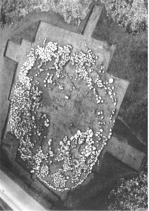
Aerial photograph of the excavation site courtesy of Researchgate.net The overall simplicity of the site stratigraphy therefore belies what may be a rather complex sequence of events, for which there is little positive evidence. The construction of a substantial limestone enclosure very early in the Bronze Age is attested not only by the metalwork associated with the two in situ inhumations, but also by the presence of two Late Neolithic flint arrowheads recovered from the cleared ground surface below the enclosure. It is difficult to ascertain the use actually made of this enclosure, although it may have contained inhumations, either exposed, laid in cells, or under individual cairns. The fairly clean nature of the truncated subsoil illustrates that this enclosure was not in use for any great length of time before being totally covered by a large cairn of smaller stone. Immediately prior to this, however, it is likely that the main inhumation was laid in the centre of the enclosure and indeed may have provided the impetus for the construction of the cairn, which would have disturbed any pre-existing burials. It is thought likely that at a later date the monument was possibly reused with the insertion of the cremations.
Although clearly related in a general way to the ring-cairn form, a number of factors do appear to differentiate the site at Manor Farm from the many ring-cairn variations identified by Lynch (1979, a & b).The absence of an internal kerb and clearly defined central space together with the fact that the entire monument, including the external kerb, was covered by an overlying cairn, probably part of the original design, particularly serves to illustrate these differences. In addition, the size of the monument (c.35m diameter), the probable number of recorded inhumations (c13), and the quality of the associated metalwork further emphasise the importance of this major northwestern Early Bronze Age funerary monument.
Notes
- Identification by C. Bendelow (Soil Survey of England & Wales, Penrith Office), and J. Keeley (Ancient Monuments Laboratory) ↩︎
- Determination by P. Howard, Experimental Officer, Department of Archaeology, Lancaster University ↩︎
- Analysis to be conducted by D. Gurney (Fenland Archaeological Associates) ↩︎
Bibliography and Further Research Data
- Gerloff, S., 1975- ‘The Early Bronze Age Daggers in Great Britain and a reconsideration of the Wessex Culture’, Prahistorische Bronzefundre. Abteilung VI. Band 2. Munich.
- Lynch, F., 1979a. ’Ring-Cairns and related monuments in Wales’, Scottish Archaeological Forum, Vol 4 (1979), pp. 61-80.
- 1979b. ‘Ring Cairns in Britain and Ireland: their design and purpose’, Ulster Journal of Archaeology, Vol 42 (1979), pp. 1-19.
- Full report available
- Supplementary Information
Published in Mourholme Magazines Issue 7 Spring 1984
By Ian Wilson
Today when one walks into many of British Rail’s stations, it is not hard to get the feel of past glory. Carnforth Station is no exception; one has just to walk through the entrance arch to see that the main line platforms have been cut back and that the building itself is rapidly decaying. It is not hard to imagine the time not so long ago when London express trains stopped here while hundreds of people moved around the platforms in the heyday of railways. Go back a little further in time, however, and one would find only a tiny halt, and indeed it is possible that Carnforth may never have had a station at all in the beginning.
By June 1840 a network of railways had come north from London to reach Lancaster. However, after this point there was disagreement about the course the line should take to Scotland. The favoured course at the time was one proposed by Joseph Locke in 1835. He envisaged a line going up the Lune Valley via Kirkby Lonsdale and onto Tebay before descending to Penrith and Carlisle. A second route was put forward by Job Bintley under the insistence of parties in Kendal. He proposed a line running through Carnforth to Kendal and up Longsleddale before tunnelling through to Hawswater and onto Penrith. A third route was put forward by George Stephenson. He suggested a barrage carrying the railway over Morecambe Bay, another over the Duddon, the line then following the coast to Carlisle, thus avoiding any high ground.
These three and other proposals were put before a Royal Commission which was set up to examine railway routes between England and Scotland. The Commission rejected the coastal line as being too long, while it foresaw difficulties in tunnelling under Longsleddale as Bintley had suggested. However, it suggested that the southern half of Bintley’s line could be linked with the northern half of Locke’s line, and this was the course that was finally adopted.
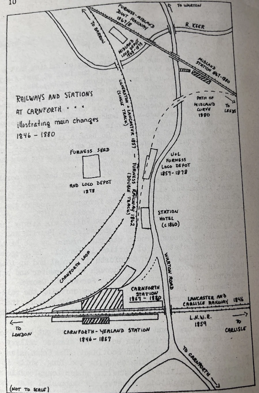
Parliamentary approval for the line was given on 6 June 1844 and work started before the end of the month. The Lancaster and Carlisle Railway Company had envisaged a single line. Demand for their shares was so great, however, that money problems vanished and a double track was built. The line opened to Kendal on 21 September 1846 and on to Carlisle on 17 December. In 1846 Carnforth was a small village mainly built along the present North Road. It would be logical for the company to provide a station for the community as one of its’smaller’ stops on the way to Carlisle. The station was named Carnforth-Yealand, indicating the unimportant nature of the village. There has been some doubt over the actual site of the first station; however, an early O.S. map shows it to have been on the site of the present day main line platforms, just south of Warton Road Bridge. Why the station should have been called Carnforth-Yealand instead of the more logical Carnforth-Warton Station is probably lost in history. The station consisted of two platforms with the station building being on the Carnforth side of the line, probably just south of the present day ticket office [Ed now Heritage Centre].
An 1850 timetable shows that just two up (to London) trains (10:50, 5:24) and two down (from London) trains (11:14, 1:51) stopped at the station with no trains stopping on Sundays. Indeed if it were not for events going on elsewhere at the time, that could have been the history of the station, opened 1846 and no doubt closed around 1970 if not before. The fact that this did not happen was due to events taking place on the Furness peninsula. In 1846 the Furness Railway Company opened a line from Kirkby in Furness to the then tiny hamlet of Barrow with a branch to Dalton. The Dalton line was extended in 1851 to Lindal and then onto the then biggest town on the peninsula, Ulverston. However, the final link from Ulverston to Carnforth was independently constructed by the Ulverston and Lancaster Railway Company. Carnforth was the logical point of junction with the Lancaster and Carlisle. The line was opened on 1 September 1857.
The coming of the Ulverston and Lancaster meant drastic changes for the small Carnforth-Yealand station. To show its new importance, ‘Yealand’ was dropped from ‘ its name, and as ‘Carnforth Station’ it now rivalled Oxenholme and Penrith as the most important station between Lancaster and Carlisle. A new platform had to be built to accommodate U & L traffic, which took the form of a triangle between the main line north and the curving new line to the west, with a new station building on that platform. A small loco depot was built just northwest of the station beside Warton Road, while a number of loop lines were built between the main line and the Ulverston line for goods traffic. The line to Ulverston was at this time only a single track.
Two years later in 1859 a new name appeared at Carnforth Station, that of the mighty London and North Western Railway, the ‘premier line’. That year the L.N.W.R. had leased the profitable Lancaster and Carlisle, which itself had previously leased the Lancaster and Preston Junction Railway and the independent Kendal and Windermere Line. Three years after the L.N.W.R. came to Carnforth, the Furness Railway arrived by absorbing the Ulverston and Lancaster in 1862. The following year the Furness doubled the line between Carnforth and Ulverston, though no new platform was added to Carnforth Station. During this time the L.N.W.R. built its own loco depot south of the station.
The next development at Carnforth started in the 1850’s when a large deposit of haematite, an iron relatively free from phosphorus used in steel making, was discovered at Park just outside Dalton in Furness. This resulted in an increased rail traffic for the Furness, particularly to Yorkshire. Trains bound from Furness to the east, however, had to reverse at Lancaster Castle before going along the single track to join the east-west lines of the Midland Company at Green Ayre.
In 1861 the Furness and Midland proposed a new line to cut out this roundabout route, the new line to go from Carnforth to the Midland line at Wennington. The line was opened to a point just east of Warton Road on 6 June 1867 with the stretch from there across Warton Road and the Keer opened on 1 July 1868. However, as trains from the east would need to reverse down the Furness line to reach Carnforth Station, a new station was opened just east of Warton Road. The steps which can still be seen between the two RR bridges on Warton Road lead up to the site of this station. All trains over this line were run by the Midland, which built a loco depot just north of the Keer in the ’V between the new line and the Furness line to the main station. Only five years later, however, the Midland found these facilities too small and the present Midland shed was built just east of the A6.
The separate Midland station lasted only a short time. Plans were made to build a curve from the Midland line crossing Warton Road and continuing on into the main station. The Furness shed, however, stood in the way, so in 1878 a new shed and loco depot were built on the site of the present shed occupied by Steamtown [Ed. Now a privately run company supplying rolling stock for heitage trains]. The obstructing shed was demolished and the curve opened on 2 August 1880, the Midland station then being closed.
The arrival of the Midland at the main station coincided with its rebuilding in a grand manner and taking on a much more familiar look. The building which now holds the ticket office [now business units] was built, with the platform being extended north under Warton Road Bridge. A bay platform was provided just south of the ticket office buildings. A large train shed was provided covering the bay line and two parallel sidings. The north wall of this can still be seen jutting out into the station car park. A canopy ran the length of the main line platform from its southern end to the end of the buildings just south of the bridge. The triangle shaped middle platform was built with two prongs, one going aside the main line, the other following the Furness curve. The Midland bay, which still can be seen, was at its northern end. The buildings which now stand on this platform were built then. No second Furness platform was built, however; up and down Furness trains still operated from the single centre platform. A large, over-all roof in Gothic style covered the Furness lines and Midland bay.
A large wall for this was built on the site of the present down Furness platform. The siding against this wall inside the shed was given the name of ’Snatchems’. The station stayed unaltered until the days of the London, Midland, & Scottish Railway at the 1925 grouping. In 1925 the L.M.S. closed the Furness shed, as three sheds for the now one company was considered extravagant.
The next changes to the station occurred during 1939-1940. The overall roof was demolished, while a new platform for down Furness trains was finally added. Shortly after this, the station was used for the station scene in the film ‘Brief Encounter’.
In 1935 the Furness shed was demolished and work started on a new shed and loco depot, which existed as ’Steamtown’ [for a period befoe becoming a private comany supplying heritage rolling stock]. The depot included an ashplant and the huge coaling tower which still dominates the town. It was opened in 1945 and at the time was the most modern in Europe. Once the new depot was opened, the old L.N.W.R. shed could be demolished, while the Midland sheds were sold to a private firm.
The station stayed the same for the next twenty years, surviving the 1965 Beeching cuts. The onset of deiselisation and electrification, however, had drastic effects on Carnforth. Steam locos operated out of Carnforth until the end of steam on BR in August 1968. On 31 March 1969 BR closed the loco depot, but by then Steamtown had been born and now flourishes on the depot site.
Meanwhile the station itself came under scrutiny in the interests of speed. The main line platforms were closed and partly demolished. The canopy on the ticket office platform was also demolished. In 1975 electrification work started, resulting in the southern approaches being changed. Electric trains started running from May 1974. Since then the remaining parts of the station have been tidied up and a glass screen added to shield passengers from the main line. Both Barrow and Leeds trains now stop at the Furness platforms, while the Midland Bay is rarely if ever used. The station is still moderately busy, most trains attracting a reasonable number of passengers. During summer months the station gets a boost by the steam specials running either to Ravenglass or York, these always attracting a large crowd. The station should remain open for the foreseeable future, though rumours circulate from time to time about the closure of either the Barrow or Leeds line. And who knows? BR may even one day reopen the main line platforms. At the moment, however, one can only dream about that.
Notes and Queries
Ian Wilson has used the earliest 6″ Ordnance Survey maps (1845-48) to show both the position and size of the first station at Carnforth. These maps also show no other station buildings between Burton and Carnforth. He notes that the station was called Carnforth-Yealand, not, as one might have expected if village size and importance had been the chief consideration, Carnforth-Warton Station. A partial explanation, I think, might be deduced from a Lancaster and Carlisle Railway Time and Fare table, dated July 1848.
On one side are the ‘Up’ and ‘Down’ schedules between Glasgow & London. Stations in our section are Lancaster, Hest Bank, Bolton, Carnforth-Yealand, and Burton and Holme. On the other side are very interesting schedules of Market Day Trains for Carlisle, Penrith, and Lancaster. The Saturday train for the Lancaster market left Burton at 9.06 am, arrived at Yealand at 9.11am, and at Carnforth at 9.19am, returning to Carnforth at 4.51pm and Yealand at 4.58 pm. Thus, there obviously was a clearly established Yealand halt for local traffic in 1848, and this fact might explain why Carnforth, Yealand’s closest station, appeared on main-line schedules as Carnforth-Yealand. What is not explained, however, is where this Yealand Halt was – and why! From NYT
The Yealand ‘Halt’ Discovered? By E.V.Foulds
To the best of my knowledge, the Yealand halt was where the signal box used to be on the A6, opposite the foot of Snape Lane. When we first came to the village in the very early nineteen- thirties, we were told that some considerable time ago there had been a suggestion that a ‘proper station’ should be built for Yealand, and the signal box was pointed out to us as its proposed position, however, the local ‘gentry’ strongly opposed the suggestion, as they preferred the village to be peaceful and secluded, whereas easy access might lead to a large increase in the number of inhabitants and an influx of day trippers. The Halt must have fallen into disuse long before our time, but some focus of activity must have remained within living memory, for we were frequently told the sad and gruesome story of a railway employee who was decapitated by a train when crossing the line at that point in the course of his duties.
Incidentally, younger members may be interested to know that even access by bus was more limited when we first knew the village than it is now. The buses turned round for their return journey at the Peter Hill bus stop, and it was explained to me that it would be not only dangerous but quite impossible for a bus to go down the steep hill leading to the New Inn and beyond.
Notes
Works consulted: David Joy, A Guide to Steamtown. Railways of Lake Counties. Railways of Lancashire.
K. Entwhistle, A History of Bolton le Sandas Ordnance Survey Maps: 1st Edition Lancashire 6″. c.1848 and c.1865.
Published in Mourholme Magazines Issue 6 Winter 1983, Issue 7 Spring 1984, Issue 8 Summer 1984
By Robin Greaves

Green Garth [Ed There are two articles which I have copied as written in the Mourholme magazines]
The main part of the house dates from 1604. It was built as a three- storeyed farm house by a Jenkinson and lived in by that family for three hundred years. Across the road are large barns and outbuildings, and there is a pump and well recently renovated. Behind the house at the top of the garden is the grave, complete with stone and urn, of James Jenkinson who died in 1808 aged 70, and was buried there ’according to his wishes’.
He was first buried in Warton but ’he did not settle’. Several times after his death he was seen walking up the road from Warton to Yealand, and eventually, after the vicar had tried in vain to exorcise his spirit, he was exhumed and reinterred where he now lies.
The ground floor of Green Garth has been much altered but there is still an old stone fireplace in the main room very similar to others in the village. It has been painted and has the motto ’Palma non sine pulvere’ written beneath the mantlepiece. Beside it is a fine old oak bureau built into a recess, with cupboards above and below it. Through a door is the original staircase which leads to the upper floors. There is some old woodwork upstairs and on the walls of one of the top rooms and on several doors are initials carved presumably by the farmhands who slept there.
In 1950 I lifted a loose floor-board on the staircase and found under it, covered with dust, a Catholic Book of Hours, bound in leather and enclosed in a brocade case lined with velvet. It is written in French and Latin and the date of publication is 1753. On the back page is written the name Peater Desbourd. Who was this secret Catholic who hid the book? Who stitched the beautiful case so carefully, even covering the button in blue velvet?
Green Garth and The Jenkinsons: a House and its History
by Carol Shaw
In 1945 my parents bought the house in Yealand Conyers which is known as Green Garth from the Miss Hardings, who had been left it a few years earlier by an ex-pupil. She was Elfrida Roper, who also owned Beechfield. She had bought Green Garth in about 1932, and had made considerable alterations to it. From the Miss Hardings, my parents learned that the house had been built in 1604, and from that time until it was sold to Miss Roper it had belonged to a family called Jenkinson who were Quaker farmers.
One of them, James Jenkinson, was buried in the copse above the orchard in 1808 “at his own request” according to the inscription on the tomb. Initials on the doors and walls of the rooms on the top storey were said to have been carved by the farmhands who were housed up there. My sisters and I were brought up on this story, and there seemed no reason to doubt it, apart from one rather peculiar circumstance: my elder sister, going up the back staircase one day, felt a sudden desire to lift a loose board and look underneath. In the dust at the back of the hole she found a small book, carefully preserved in a case made of brocade and fastened with a button. The book proved to be a Catholic breviary, Heures a Trois Offices, l’usage de Rome dated 1753, with the name Pieter Desbourdes in the back.
What was a Quaker farmer doing harbouring a Catholic, and, by the sound of his name, a Frenchman? Was he being persecuted, and did the Quaker family take pity on him? Why did he hide his breviary under the stairs and leave it there? There were no further clues. Years later, several things began to make me question the established story.
My husband, looking at the initials in the top rooms, remarked that they must have been very small, and very literate farmhands. “If you are carving your name on a door, you normally do it at shoulder height, and some of these initials are only three feet or so from the floor.” Certainly the letters, with their elaborate serifs, are not what one might expect from rough eighteenth century farmhands. Might they, he wondered, have been not farmhands but schoolboys from the Quaker school down the road, boarded out with a friendly farmer?
I made a list of the initials and went down to the Meeting House to compare them with those carved on the door there. Many of them tallied. My sister, researching into early seventeenth century wills, found no record in them of any Jenkinsons in Yealand, which was odd. If they had lived in such a large house from 1604 onwards, surely there should have been some wills. There certainly was a Jenkinson family connected with the house. Apart from James in the orchard, my mother had been visited in the 1950’s by Jenkinson descendants wishing to see the tomb.
My brother-in-law suggested I should try to trace them in the old Quaker minute books still kept at Yealand Meeting, so I borrowed them and read my way through the 1670’s, 1680’s, 1690’s. No Jenkinsons. I found the first mention of the name in March 1729, when Michael Jenkinson was appointed schoolmaster at Yealand for one year. He was still there in 1733: “Michael Jenkinson our present master…is to teach all poor children belonging to this meeting and all others who are of ability.” In 1734 he married a local girl, Ruth Robinson, and settled down to produce a large family and presumably continued to teach at the school. There is no mention of where they lived.
Two of Michael and Ruth Jenkinson’s sons, John and James, later played an important part in the Meeting’s affairs, being appointed to several committees, travelling to Manchester and to London, _ and entrusted with various business matters. John is described as a schoolmaster and a yeoman. Both he and James rented land from the Meeting and in 1764 it is recorded that John bought a “dwelling house and also the close called Overcroft.” He also paid £30 for the alteration of a house which Friends bought in 1763 and converted into a school. There seems no way of telling whether either of these houses has anything to do with Green Garth.
In 1778 John married Margaret Hall of Height, and they had three children. He died in 1796, and his wife Margaret in 1813. The children seem all to have left the Society of Friends, since there is no further record of them in Quaker sources. Ruth, the eldest, certainly left: she married Mr Clarkson of Brackenthwaite in Warton church, and was eventually buried at Cartmel Priory.
James, Michael and Ruth’s other son, is a more shadowy figure, He never married (or, at least, no such marriage is recorded in Friend’s records). He was active in the Society, and in 1768 transferred his membership for a time to a meeting in London (another place to look for evidence of his activities). In 1775 he published A Generic and Specific Description of British Plants, so he must have been something of a scholar and a naturalist. He and John appear to have been involved in a printing and publishing business at one time – there is a pamphlet printed by “J. and J. Jenkinson, Printer of Yealand” *in the Lancaster Reference Library.
There is a curious note in the Meeting accounts: In 1802 James Jenkinson bought the school house and garden”. It is unlikely that this was the present Old School, since it still belongs to the Society of Friends. Was it Green Garth? James certainly owned the house when he died in 1808. He is described in Friend’s records as being buried “in the croft above his house at Yealand Conyers”. In quite another context I came across a letter on “Antiquities in Lancashire” written in 1788 by a William Hutchinson to George Allan Esq1. which refers to “British remains in the parish of Warton” and continues “Mr Jepkinson, who conducts a great seminary at Yelling, where he teaches the languages, conducted us through the scenes of antiquity…..At his house he showed us two urns which his workpeople recovered from cairns levelled down within his new enclosures on the skirts of Warton Crag.” It is fairly safe to assume that for “Jepkinson” we can read “Jenkinson” and for “Yelling”, “Yealand”. Mr Jenkinson was presumably John, the schoolmaster, who was by this time, it seems, a prosperous farmer, reclaiming land on the slopes of Warton Crag. This could have been the land above Green Garth, which could have been the house Mr Hutchinson visited. But still no proof. There is a lot more work to be done. The next step is probably to go to Preston and see whether the Lancashire Record Office has any record of John or James Jenkinson purchasing a house in Yealand Conyers that could be Green Garth. Meanwhile, James still sleeps above the orchard, and I am still intrigued.
- William Hutchinson 1732-1814, and George Allan 1736-1800. Both distinguished antiquarians in their day, both Fellows of the Society of Antiquaries. It was Allan who encouraged his friend to publish his “Account of the Antiquities of Lancashire”, Archaeologia ix 211-18. 1788. ↩︎
Published in Mourholme Magazines Issue 7 Spring 1984 and Issue 19 No 2 1992
By Margaret Clarke
W. G. Hoskins in his essay, ’The Re-building of Rural England 1570-1640′, was the first to bring to the attention of local historians the fact that in many parishes numerous houses were being rebuilt or enlarged at this time. His evidence came from the Midlands and further south generally; in the north the rebuilding commences a little later, from about the middle of the 17th century. All the villages in the ancient parish of Warton and neighbouring areas have houses dating from the 17th century onwards. These houses are generally rectangular in shape and only one room deep. Some are easily recognisable where the stone mullioned windows have been retained; others are concealed under roughcast rendering and disguised by the replacement of windows in the 18th and 19th centuries.
In this article evidence from Probate Inventories is used to show what sort of houses the people of Burton in Kendal were living in during the late 17th century and how the interiors were adapted to their needs.
Probate Inventories, which list all the goods belonging to a deceased person at the time of death, give contemporary information about the house the deceased person lived in, especially when the goods are described as being in named rooms.
The main living room of houses in the north in the 17th century was variously called ’the house’, the firehouse’, ‘the bodystead of the house’, or ‘the kitchen room’. This ground floor room contained the hearth where all the cooking was done. In early houses a second ground floor room was known as a chamber. This room usually having access only through the firehouse, was a more private room, and was used as a bedroom and a repository for more valued goods. In later houses which had rooms on a first floor, a second ground floor room was called a parlour and the upstairs rooms were then called chambers.
The earliest inventory examined is that of Frances Clauphton, who died in 1646. Only one room is named in her inventory, the chamber. However it must be assumed that there was also a firehouse. Early houses had either one or two rooms only (a firehouse or a firehouse and chamber), which were open to the ridge of the roof. The main entrance generally opened into the firehouse more or less in the middle of the long front wall of the house, although in some cases it may be placed in a gable wall adjacent to the hearth, which in most of the 17th century and early 18th century houses in North Lancashire and South Westmorland is in the gable wall. (see magazine article for a drawing)
John Lucas, yeoman, died in 1674 and is described ‘of Burton Hall’. The house described in his inventory contained two named rooms, a parlour and a loft, and there was also by implication a firehouse. In the Hearth Tax assessment of 1669 he was assessed for two hearths, so both the firehouse and parlour contained a hearth. The upper floor of the house is one large loft area covering both downstairs rooms and is open to the ridge. (see magazine article for a drawing)
Robert Claughton, husbandman, who died in 1674, had a house containing a parlour and a chamber above, and other chambers. His house has two rooms on the ground floor with a ceiling over, and the upper space had apparently been divided to form a number of rooms which have been ceiled over also, since there in no mention of a loft. His will mentions a ’new chamber’. (see magazine article for a drawing)
Thomas Claughton, husbandman, who died in 1716, was also described ’of Burton Hall’. His inventory includes ‘Goods in the Parlour…in the Parlour Loft… in the firehouse…in the buttery. (This does not appear to describe the same house as John Lucas’s inventory of 1674). Downstairs there is the usual parlour and firehouse, but an additional room is named – a buttery. Upstairs there appears to be one room situated ‘over the parlour. The firehouse apparently still remains open to the ridge (see magazine article for a drawing).
A buttery was sometimes incorporated within the structure of the main building, but was more commonly accommodated in an outshut together with a staircase. This relieved the pressure on the living area in these narrow houses. The provision of a service room or store usually called in this area a buttery is a new feature of houses in the north during the latter part of the 17th century.
Robert Hutton who died in 1699 lived in a house with a loft, a little loft, a parlour, a buttery, a fire house, and a stable. His house could have been with a ceiling over the firehouse and parlour and the upper part still open to the ridge divided into two areas, the little loft over the parlour and the loft over the fire house. The buttery is shown in an outshut.
These are the simpler houses described in the inventories and could be represented by houses such as Hornby House, Hordley House, Ivy Cottage, and the west wing of Old Hall. ‘The difference in building materials, particularly the stone quoins, suggest that the central and east-wing of Old Hall may be later additions.
These late 17th century houses have been built for families dependent upon agriculture as their means of support and are essentially rural in character and similar to many others in the villages of S. Westmorland and N. Lancashire.
Some inventories show that trade is becoming a significant feature of the economy in Burton. Sir George Middleton of Leighton Hall was Lord of the Manor of Burton and received a Charter from Charles II in 1662 for a weekly market to be held there on Tuesdays. The market thrived mainly as a result of the corn trade. The county of Westmorland imported large quantities of corn, mainly oats from neighbouring areas, and Burton market became the trading centre for corn brought in from Lancashire.
Thomas Greenwood, who died in 1683, was a blacksmith. His inventory mentions chambers, lofts, a buttery the old loft, a smithy, a shop and cellar and another cellar, his house does not include a parlour, so probably the shop was situated in the space usually occupied by the parlour. The first floor appears to be ceiled over and the loft area between the ceiling and the ridge appears to have been utilised and partitioned into smaller areas. At this time cellars were not necessarily under the ground floor but could have been at a lower level possibly in an outshut (see magazine article for a drawing). In his shop and smithy Thomas Greenwood had a vast range of goods. he was obviously supplying more than just the local community of Burton, as was Christopher Dickinson, who died in 1709. Goods in his shop were valued at £90 and he had debts owing to him totalling £95.6.8d.
Robert Hinde’s inventory (1708) also includes commercial as well as domestic accommodation. His house contained the bodystead of the house, a brewhouse, a buttery, a cellar, a buttery loft, great loft, house loft, closet, and in addition a smithy loft, a shop, and over barn, a hay barn and great barn are named. In order to provide more storage or service space an outshut was extended along the whole length of the house at the rear, and it may be that the brewhouse and buttery and possibly the closet were in such an outshut, with a ceiling over, forming a loft area above. It would appear that the area above the bodystead or main living room is still open to the ridge, although it has been partitioned. The shop could again be in the space usually occupied oy the parlour, since no parlour is named.
These few inventories show families in Burton adapting their new stone houses to their changing needs as the money becomes available to finance these activities. Few documentary records describe these early houses (Glebe Terriers do sometimes), so Probate Inventories are valuable in providing information during this transitional period.
Notes – Sources consulted:
- W. G. Hoskins, ’The Rebuilding of Rural England’, in Provincial England (1965).
- R. W. Brunskill, Vernacular Architecture of the Lake Counties (1974)
- M. W. Barley, The English Farmhouse & Cottage (1961).
Published in Mourholme Magazines Issue 7 Spring 1984
by J.D. Marshall [Ed: This is an amalgamation of three separate magazine articles]
The old Ward Lock Guides to towns and regions of England were in the habit of remarking upon ’Literary Associations’, and upon authors of note who had written about the districts concerned. Should these things concern a serious local historian? It is true that far too much of our time is spent in front of a flickering screen, which trains us in mental rubber-necking which does not, at the same time, involve us in any real effort, ‘we are too accustomed to the ‘ooh-think-of- that’ kind of appeal, to the satisfaction of idle curiosity. To what extent, then does it matter that famous people have trodden our lanes and looked at our magnificent scenery and – perhaps – written about it?
I think (with some reservations) that it does matter. A good and vivid writer will tell us things about our own historic landscape that we might not appreciate, or that we might not have noticed. Sometimes such a writer’s descriptions have real documentary value, and, at the very worst, a rather unfashionable or stilted author will at least tell us something about the attitudes and values of his or her own age.
Mrs Elizabeth Gaskell
The Mourholme Society’s territory is exceptionally blessed in that it has had some literary attentions from remarkable people. In at least one case, the writer’s observations were not meant to be published, but appear in private letters. Many readers will know that Mrs Elizabeth Gaskell, one of the most famous ‘social novelists’ of Victorian England, was in the habit of taking holidays at Gibraltar Tower, Lindeth, in the 1850s, and, fortunately for us, she wrote about it at fair length. Her letters were published in 1966, edited by Chapple and Pollard, and they contain numerous insights into local life. The difficulties of getting supplies of provisions are mentioned in June 1858, and Mrs Gaskell wrote:
‘Silverdale is so wild a place we may be happy to get a leg of mutton at all. I have had to dine 15 people as hungry as hounds, on shrimps and bread and butter and when they asked for more to tell them that there was no bread nearer than Milnthorpe 6 miles off, and they had to come down to oatcake and be thankful.’
Mrs Gaskell, in the original letter, even gives us the the pronunciation of Milnthorpe (‘Milthrop’), and, for the rest, we are sharply reminded that carrier’s carts were apt to be slow or non-existent, and that a Victorian family could face real privation in taking a holiday.
The habit of fairly well-to-do Victorian families was to rent houses for holiday purposes, and to stay away from home for up to a month. Hence, in an undated letter (c1850), Mrs Gaskell writes about ‘our annual migration to the sea-side’, and, during a longish stay, one could acquire numerous guests. Mrs Gaskell added: ’And we are keeping holiday in (the) most rural farmhouse lodgings, so that our children learn country interests, and ways of living and thinking.‘ In 1852, she was at the Lindeth lodging again, and she remarked: ‘We may have the tower-house at any time, but there it was so close’. (Here, then, is solid evidence – she did stay in this edifice, as the story goes, but historians are often right to distrust literary folk, and there is considerable tension and suspicion between the two interests! The history of the Lake District is bedevilled by scribblers who repeat each other’s stories, but let that pass). Nor was the closeness, or fug, in the Tower the only problem; letters tended to get lost in the country lanes, and the place swarmed with poultry, and, no doubt, their characteristic scents. But Mrs Gaskell helped in the tasks of the adjoining farm as well as entertaining guests. She also used Silverdale as a base for visiting eminent friends in the Lake District, and travelled to Kendal, and then to Windermere to meet, among other people, Mrs Wordsworth and the widow of Dr Arnold at Fox How near Rydal.
She was again at Silverdale in the August of 1855, and seems to have been in and out of the place from July to early September. She was excitedly collecting material for her famous Life of Charlotte Bronte, Three years later, she explained why the Morecambe Bay scenery so entranced her (in a letter of 25 July 1858):
I think – and it is pleasant to think — that one is never disappointed in coming back to Silverdale. The secret is I think in the expanse of view – something like what gives its charm to the Campagne – such wide plains of golden sands with purple hill shadows – or fainter wandering cloud-shadows, & the great dome of sky – (We have not sate up all night on our tower this time, partly because there have been no tranquil nights…)
So, we know what the Gaskell family did as a special treat when the weather was suitable. They sat on the top of the famous tower, doubtless watching the moonlight spraying across the damp sands when the moon was in the right quarter, and, perhaps, watching the sunset in the evenings, and feeling the impact of the dawn to landward in the early morning. And here is a comment on the changes of over a century. The countryside really was quiet in those days, and one could find blessed peace and solitude. This passage could have been quoted to the irresponsible and insensitive people who wish to dam up the Bay and to turn it into a still pond for motor boats.
Let Mrs Gaskell make a few more comments. It should be mentioned that she visited Poulton (Morecambe), Grange, Seascale and other places in the area. But she and her family were still visiting Silverdale in the summer of 1861, and their connection with Morecambe Bay plainly lasted for over a decade. Their descent on Lindeth, which commenced in the July of that year, had its disadvantages. The post was not only dreadfully slow: the postman rode a pony ’almost as old as himself to Lancaster every morning to fetch the letters; delivers them to Yealand; walks here; gets thirsty on the road; drops his letters, or forgets in which of his various pockets he has put them…’ The family, it appeared, were starved of reading matter, and our local resorts had a long way to travel before they became more than ‘adventure playgrounds’ of a testing kind.
Elizabeth Gaskell died suddenly in November 1865. Many members of the Mourholme Society will have read her Mary Barton, or North and South, or Cranford (a description of her home town of Knutsford, and the most delightful of all). Her home at 84, Plymouth Grove, Manchester, is safely in the hands of that city’s university, and has become a museum dedicated to her. When we visit it, we shall also remember that she forsook it sometimes to visit our own lanes.
Edwin Waugh
The opening of the railway line from Carnforth to Ulverston (1857) brought numerous travellers and settlers on the fringes of Morecambe Bay. One of the most remarkable visitors by rail, one who had a great affection for Silverdale and its district, was the Lancashire dialect writer and topographical author, Edwin Waugh (1817-1890).
Waugh is perhaps best known for certain dialect poems, like ’Cum Wham to thy Childer an’ Me’ and ’Besom Ben’, and he lived through, and partly created, a great resurgence of dialect writing in his home county. Like many of his fellows, he had to ’addle’ a living in ordinary pursuits for much of his life, and until the age of forty, he worked as a journeyman printer, secretary and salesman, chiefly in the environment of industrial Manchester, which he heartily disliked. Like many thousands of intelligent artisans, he had a profound hankering for the countryside, and had, as a young man, been drawn into the exploration of the Lancashire moors. In his first published volume, Lancashire Sketches (1855), he exploits the possibilities of local speech to the full, and, just as interestingly, he was later enabled to do so in the case of Lonsdale and the Lake Counties, especially when he published a further volume, Rambles in the Lake Country and its Borders (1861)1.
It will be noticed that this was written soon after the opening of the through coastal railway route. Indeed, the last mentioned book contains numerous references to the railway:
’Before the railway was made, the old way of crossing the sands from Lancaster to Ulverston must have been very striking..,(p.44); ‘the new line of railway from Lancaster to Ulverston winds by Silverdale, with the grand features of land and sea full in sight’ (p.47).
Surely this sounds just like a guide book? Yes, indeed, this is just what Waugh was really writing. He was advertising our quiet corner of England in persuasive style, resting his approach on the new accessibility of the area and the growing taste for travel which was now reaching to the artisans as well as the ‘middling’ groups in society. He has a highly personal style, loaded, it is true, with the usual Victorian clichés and phrases; but, all the same, it succeeds in being fresh and lively, and one can be sure that he has really looked at the area he is writing about. His evocation of Grange-over- Sands is superb, giving us a picture of the Crown Inn before it had reached its later uninteresting respectability. And, of course, one should never forget that he helped to make our own area popular, or fashionable. Since the great majority of our students of local history are ’offcomers’, we must feel some sympathy with Edwin Waugh.
In Rambles in the Lake Country, there are three complete chapters, making a ‘Book’ on its own near the end of the volume, with ‘Silverdale’ as the subject. In the opening sentences, Waugh remarks
‘I sometimes think it strange that I should have lived so long in Lancashire without hearing of the place before’.
Not too surprising, for the author was raised in Rochdale, a very different place, and was a young man when the first railways were built. He goes on to say that ‘the life of this retired spot is all rural repose‘, and he keeps to the theme consistently. He writes of the ‘quaint manners, language and peculiar way of life of the inhabitants’. He used the Silverdale station as his starting point, and turned left towards Slackwood and Silverdale Green, but remarks that Silverdale itself is hardly a village; there is only a ‘village part… nearest to the sea, where the two hotels, and the little hat-full of a post office, with three or four other dwellings, stand within a few yards of one another’. The author asks for ‘Mister Fawcett o’ th’ Victoria Inn’, and there was indeed such a place at that time, as well as a post office and grocery – both appear in the Mannex Directory of North Lancashire for 1865. The ‘Victoria’ was ‘a large, plain white-washed building upon high ground’, and the author discovers later that his bedroom in the inn was used by the Salford M.P. Joseph Brotherton, a famous campaigner against the Corn Laws. There are other bits of local history: ‘This is the table ‘at old Lord Derby’s steward used to receive his Arnside rents on’.
Waugh, like Mrs Gaskell, looked with fascinated eyes at the awe-inspiring sweep of the tide-empty sands: ‘Out towards Lancaster the water was in full sight, bright and smooth as a mirror’. He noted the existence of a solitary cottage known as ‘the Bath House’. More strikingly, he noticed a drove of cattle on their way from Kents Bank to the Warton shore, another piece of striking lore, because one does not usually think of the Bay as a drove road! Yet it plainly was one, and, of course, cattle regularly crossed the Solway sands in the same manner. The landlord later tells him that ‘if you’ll be up in good time i’ th’ mornin, you’ll see maybe eighty or a hundred fishin’ boats in the bay – like a fleet cornin’ up to tak th’ place’.
So, the shrimping and other vessels were as numerous as that, even in 1860, before Morecambe had properly appeared. These evocations of rural peace and quietude were, of course, enjoyed when the Carnforth furnaces had not been built, and when Barrow’s first ironworks was only beginning to smear the horizon with its smoke. Meanwhile, it is not likely that Waugh was inventing many, or any, of these observations, because he had a remarkable ear for speech, and he paints pictures of individuals emitting dialect and strange expressions. The impression, much of the time, is of a silence so unearthly that one can hear the sea going out or coming in across the Bay – not something that most of us notice today. At the same time, it should not be thought that Waugh was so sensitive that he painted scenes different from those of most other people; it was simply that he came from industrial Manchester, where the iron tyres of drays and lorries were beginning to make a frightful noise on the flags of the streets, and where hooters, whistles and buzzers were becoming the rule. Likewise, Silverdale was very thinly settled; one had to look hard to pick out the houses. We need the assistance of vivid writers to interpret the quality of life and scenery in the past.
Local history is not all ’facts’ of a down-to-earth kind; it calls for imagination in order that it can be properly understood. We are lucky that Edwin Waugh visited the district when he did.
Many of the ’literary associations’ of our area are mere accidents, glancing and fortuitous. How could it be otherwise? Hundreds of distinguished people have passed through Carnforth station on their way round the Bay, all of them carrying their own unforgettable impressions of the district, and some of them taking away images that were less than pleasant.
I recall that Lord Bullock, somewhere in his writings, describes how he stood on Grange-over-Sands station and heard the news of the outbreak of the last war. Our area has attracted distinguished scholars of one kind and another, and one only wishes that more of them had written about it. On another occasion, however, one of the most gracious of our novelists in this century did leave a charming note behind her. Many members of the Society will have read, and been enthralled by, Winifred Holtby’s South Riding. Much of Winifred’s story is told in Vera Brittain’s Testament of Friendship, and her personality is immortalised in Winifred’s own letters, which have been published (Letters to a Friend, 1971). One can imagine this tall, eager, unspoilt young woman journeying through Carnforth one autumn day in 1922, when memories of the war, and university, were still keen. Alas, she did not say anything about Mourholme territory, but, on her way to lecture in Seascale, she did stop in Grange, and wrote a letter ’On a rock by the sea at Grange-on-Sands, Oct. 9th:
‘The station comes right up to a rocky beach, and is practically washed by the sea. It’s a glorious day, windy and sunny, with seagulls blowing about the air, so down I came to a rock…The sea in front of me is molten steel. The sky is a faint, steelish blue, and there are sea birds crying. I wish that my paper could smell of salt for you…‘
Published in Mourholme Magazines Issue 5 Autumn 1983, Issue 6 Winter 1983 and Issue 7 Spring 1984