
By David Peter
The enclosure of common lands in England went on slowly but steadily from the 15th century onwards. Originally much of this was achieved by local agreement, but from 1750 on into the 19th century there were many enclosures by Parliamentary decree. The Warton Enclosure Act dealing with the ’Commons and waste grounds’ was dated 1811.
By enclosure is generally meant the process by which estates composed of large open arable fields, divided into strips and supplemented by meadow, wood, and wasteland for pasture, were converted into aggregates of smaller fields, which were then fenced and held in private ownership.
Much information about a village’s history can often be gleaned from the names of its fields, and this is certainly true in the case of Warton.
The following account is based largely on the information contained in the Warton Tithe Award of 1846 (following the Tithe Commutation Act of 1856), which gave details of field names and the use to which the fields were put (arable, meadow, pasture).
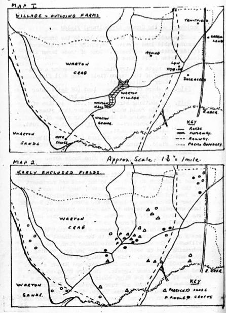
At that time Warton was a rural parish, with a population in 1851 of 600 (including Lindeth). The village consisted basically of a string of houses lining both sides of Main Street and closely associated with the Church, the school, and a number of inns. Apart from this concentration of population there were just a few fairly large isolated farms scattered over the rest of the Parish, e.g., Coat Stones, Town End, Warton Hall, Hyning, Low Hyning, Dock Acres, Tewitfield (Map 1).
Early Field Enclosures
It is impossible to discover exactly when the fields in the village first started to be enclosed. What is certain is that the first enclosures were of relatively small areas closely adjoining the homes of the villagers (Map 2). This process occurred gradually, and by mutual consent, over a long period of time. These small plots were described variously as Crofts, Garths, Parrocks, Closes, Pingles, etc. Apart from such general names as these, the fields usually had one or more descriptive words attached to them in order to help identify the owner or the location more exactly: for example,
- Nelson’s Croft, Susan Taylor’s Parrock, Waithman Close (personal names);
- Great Bailiff, Lawyer Potts, Parson’s Wall (occupational names);
- Barn End Croft, Kiln Close, Sand Close, Well Parrock (significant local features);
- Wheat Close, Crab Tree Close, Calf Parrock (crop or livestock names).
Some names are colourful, but their significance is no longer apparent: Neckcloth, Paradise, Wallott, Slapestones.
Apart from the houses and their crofts, the rest of the land in the village was divided between the open fields in which the main crops were grown, meadows for sheep and cattle, and waste land (including woods) which provided timber and game, and acorns and beech mast for the pigs. In a village there were usually two or three tillage fields. In a typical two field system, one (in rotation) was always fallow; the other bore all the year’s crops (wheat, oats, barley, peas, etc.) In the three field system, the rotation was (l) winter corn (wheat, rye), (2) spring corn (barley, oats) and peas, (3) fallow. There is no real evidence as to the precise system of land utilisation practised in Warton. Lucas, however, does make reference to the methods used in neighbouring ‘Carnford’. He states that in the western part of Carnforth ‘
…are five large common Fields; one of which goes by the single Name of Thwaite: the other four which are contiguous to each other are called Huthwaits.’ In one of these four ’…every Man plows or mows his Part as he judges most proper; and so this Field is never pastured; but in the other three…the Proprietors ’plow one of them for three Years, then laying it, they plow the next for three Years, and afterwards the next; so that they are alternately three Years Corn and Six Years Pasture.’1
Enclosure of the Common Agricultural Fields
The ancient terms which related to the unenclosed common arable land survive frequently in the names of fields created by enclosure. Some of these terms with their Warton field names are
- Flatt – a north country dialect word meaning a division of the common field: Long Well Flatt, Kerr’s White Flatt.
- Dale – a share of the common land (Old English (OE) dal): Water Dale, Robinson Dale, Little Briar Dale.
- Butt – an abutting strip of land, or a section of arable field which is shorter than other pieces owing to the irregular shape of the field boundaries (ME butt): Great Goose Butt, Little Goose Butt.
- Field – an enclosed piece of land (OE feld): Gibson Field, Church Field, Well Field, Tewitfield.
- Acre – a plot of cultivated ground (OE aecer, ON akr): Dock Acre, Half Acre, Nine Roods Acre.
- Land – a strip of land in the common field (OE land).
Reference to Map 3 will show that most of the above named fields are to be found to the east, and northeast of the village. To be more precise, they lie east of the Yealand Road, extending as far as Tewitfield, together with an area of land on the south side of Borwick Lane extending eastwards to the parish boundary. This was the East Field. By virtue of its size, this area might well have been farmed as two fields.
In addition, the field names suggest that there was a smaller cultivated area to the southwest of the village in the vicinity of Cote Stones Farm, and now embracing land on both sides of the low road to Crag Foot and Silverdale. This was the West Field. Suggestive field names here are Stony Acre and Hudson’s Acre, and Higher and Lower Dugdale. The term Rigg as found in the field name Bye Rigg, could have reference to a ridge or to the ridge and furrow system of ploughing (OE hrycg, ridge). The name Haggs, also found in this area, means an enclosed piece of hay land or meadow (OE haegg). Hereabouts also we find field names which suggest they have resulted from the clearance of a wooded area, such as Riddings (0E ryding, a clearing) and Stubbins Medieval English (ME) stubbing, cleared land with many tree stumps).
Further Enclosures
The villagers had rights over the adjoining meadows and waste land. The meadows, once the hay had been gathered, were available as common pasture. The wastes were used all the year round for pasturing the village animals.
The enclosure of the rest of the countryside no doubt also took place gradually over a long period of time. Here again it is impossible to allocate precise dates to the process. The many areas involved would continue to be known after enclosure by the names which had identified them previously, and thus could be immediately recognised by the villagers. Once such an area had been taken into use, it was divided into a number of portions depending on its overall size and the number of claimants. Each of these fields then had a descriptive adjective added to its generic title to distinguish it from the adjoining fields. Such adjectives were usually High or Low, Large or Small, Near or Far, etc.
The following are the most important of these outlying areas. They are described in a sequence starting in the northwest and continuing round the village in a clockwise direction, finishing in the southwest. They are to be found mainly to the east and south of the village (Map 4).
- Above Town (9 fields). The name is self-explanatory.
- Coat Slack (6 fields); From OE cot, a cottage or hut and Old Norse (ON) slakki, a shallow valley.
- Dawes Park (4 fields). Dawes may have been a family name. ’Park’ was applied to any large area of grassland.
- Hinelands (5 fields). From ME haining, an enclosure, and obviously derived from Hyning which they closely adjoin.
- Threagill (3 fields). Origin of name obscure.
- Parks (9 fields). The name suggests parkland such as might be associated with a large and important residence.
- Halsteads (1 field). From OE halh, a residence hall, and OE stede, a farmstead. This very significant single field coincides with the site of the old Mourholme Castle (as identified by the Warton Local History Group in 1976). It adjoins the Parks on their eastern side and now forms part of the gravel excavations.
- Well (8 fields). Associated with Senset (a contraction of St. Oswald) Well.
- Storesbrigg (4 fields). ’Stores’ suggests ON storth, a brushwood, and ’brigg’ means a bridge.
- Bailiff (3 fields). Among the meanings of Bailiff are law officer and agent or steward to a land owner.
- Gales (7 fields). Could refer to ‘gale’ meaning Bog Myrtle or to ‘gale’ meaning a periodic rent payment.
- Larnds (4 fields). A laund is an open space among woods (a glade) or untilled ground (pasture).
- Eldram (7 fields). Derived from Ellerholm, ’eller’ meaning alder trees and ‘holm’ a small island.
- Myers or Moss (3 fields). Obviously a marshy area, liable to flooding, as it still is today.
- Hazelhead (6 fields). A ‘head’ or higher ground favouring the growth of hazels. Whinns (5 fields). A place noted for its gorse.
- Bank (9 fields). From ME banke, a hillside or slope.
- Scout (3 fields). From ON scuti, high rock, a precipice.
- Ings (6 fields). From OE eng, outlying meadow land. It could be a diminutive of ’saltings’.
- Meadows. The fields described as meadows were water meadows. They are concentrated in certain parts which are low lying and liable to flooding. There are four such places:
- 1) Along the banks of the Whitbeck near to its confluence with the Keer (10 fields).
- 2) Further downstream alongside the river Keer itself (7 fields).
- 3) Flat land between the Weir in Warton village and Millhead (7 fields).
- 4) Several isolated meadows in the area between Sand Lane, the lower Crag Road, and the sea (5 fields).
There were also certain significant man made features in and around the village, all perfectly familiar to the people living there, whose names were used to identify the fields in close proximity to them: Milldam (3 fields). Millhead (6 fields), Windmill (1 field called Windmill Hill), Kiln (at least three limekilns with the fields lying nearby), and Toll Bar Field, at the junction of Sand Lane and the lower Crag Road (a toll road).
Warton Crag
The Crag, which rises to over 500 feet, occupies approximately one third of the area of Warton Parish. Ultimately, all of it was enclosed, but the divisions here were referred to in the Tithe Award merely as Intacks or Allotments, with a single exception which bears the intriguing name ‘King’s Allotment’. Because of its rocky terrain, the bulk of the Crag area was suitable only for pasturing sheep and goats.
There is however an interesting exception to this. On the north side of the upper Crag road, half way between Warton and Crag Foot, there is a farm called Scar Close, lying in a shallow valley. The valley possesses a reasonable depth of soil, and occupies a sheltered position facing south. In the Tithe Award, the land hereabouts is shown divided into a regular pattern of fields, but none has a special name.
Enquiries from the present owner as to the names of the fields do not suggest that they are of any great antiquity. They bear little or no resemblance to the patterns described above. The names he gave appear to have been inherited from a previous owner who went in for poultry keeping on a large scale: Leghorn Field, Arks Field, and Testing Field. Others indicate other uses to which particular fields had been put at one time: Meadow Field, Oat Field. Others such as Topside, Bottomside, Top Field, and First Field are obviously related to the farm and its outbuildings, whilst Red Tile and Behind the Barn have reference to detached farm buildings in the fields.
There is one field name here however which is of particular interest. It is known as ’Cemetery’ because in it is the grave of a previous owner, a certain Miss Barton, a daughter of Mr Edward Barton, Manager of the Carnforth Iron Works. She lived and died at Scar Close and opted to be buried here alongside her favourite hunter.
Conclusion
May I say that I would welcome comments on the above article, either to me personally or through the editor of this magazine. There must be many members of the MLHS who are much more familiar with the Warton scene than I am. Any suggested additions, variations, or corrections will be carefully noted. Finally may I express the hope that other members of the Society may be prompted to pursue a similar enquiry in their own locality, so that eventually the Field Name Survey may embrace the whole of the ancient parish of Warton.
- History of Warton compiled 1710-1740 (1931) pp 133-5 ↩︎
Published in Mourholme Magazines Issue 8 Summer 1984